TPACK for Google Earth Virtual Tour
Content: What is the content you'll be using in your lesson?
The content that I will be using in my Virtual Tour lesson is 5th grade Social studies Standard 4, Objective 1, Indicator C, which states, "Compare the trails that were important during westward expansion (e.g. Oregon, Mormon, Spanish, California)." This content is very important in learning how the 19th century was really a time of change and much expansion. This Oregon trail played a very large part in the expansion of America along with the Mormon, Spanish, and California Trails.
Pedagogy: What is the pedagogy you’ll be using and why is it a good fit with the content?
The pedagogy for this lesson would be discovery learning along with observations and inquiry thinking. This pedagogy fits with my content because the students will discover new skills (such as carving in stone like the people who trekked the trail) and through seeing the trails and where they lead to. This helps their inquiry learning because they can see beyond the maps and begin to question what these people had to endure and for what reasons they may have traveled on this long trail. The observations will be done in journal entries related to the sites along the trail where they can record their thoughts and think deeper about the events and sites along the Oregon Trail.
Technology: What is the technology you’ll be using and why is it a good fit with the content and pedagogy?
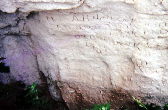
The technology I will be using for this lesson is Google Earth. I will create a virtual tour of the Oregon Trail. There will be a path drawn starting from Independence, Missouri ending in Oregon City, Oregon. It will pass through the various sites they traveled on the Oregon Trail and will include pictures of 5 of the most significant sites along the way. This fits very well with the content and pedagogy because the students can see the trail and see the distance and also see the terrain and real-life pictures along the trail. This use of technology can help them with their inquiry thinking because they can see the monuments and the pathways and understand more of what the people who traveled on the Oregon Trail thought and experienced.
avery print my own labels
-
*Free Label Printing Software Avery Design & Print*. WebUSA. Avery Design &
Print Online is so easy to use and has great ideas too for creating unique
l...
2 years ago